TTP

Maps of Bodrum & Marmaris, Turkey


Home
Search
Site Index
Turkey Maps
Photo Gallery

Where to Go
When to Go
Where to Stay
What It Costs
Transport
Travel Details

Tours & Routes
Special Interest
Consultations
TTP Forums
Funny Stuff
Shopping
Bright Sun

About Us
Contact Us
Disclaimer
©TIE 2004-2008


Bodrum-Marmaris Region Map, Turkey

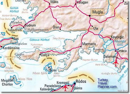
Here's a map of Southwestern Turkey where the Aegean coast meets the Mediterranean coast, including the towns of Bodrum, Dalaman (and its important airport), Datça, Köycegiz, Ören, Ortaca (where you turn off the highway for Dalyan), Marmaris, Milas, Mugla, and

Also shown are the Greek islands of Kos, Nisyros, Rodos (Rhodes), Symi and Tilos. In summer, there's frequent ferry service from Bodrum and Marmaris to Kos and Rodos.

The major airports are Milas-Bodrum (BJV) and Dalaman (DLM).

For more detailed fold-out maps of Bodrum, Dalyan, Köycegiz, Marmaris and the Aegean and Mediterranean coasts, click here.


Maps of Turkey

Transportation

Site Index

Turkey Travel Planner Homepage


Maps of Turkey shipped anywhere in the world (use Promotional Code HNE6408).