Home
Search
Site
Index
Turkey
Maps
Photo
Gallery
Where
to Go
When
to Go
Where
to Stay
What
It Costs
Transport
Travel
Details
Tours & Routes
Special
Interest
Consultations
TTP
Forums
Funny
Stuff
Shopping
Bright Sun
About
Us
Contact
Us
Disclaimer
©TIE
2004-2008
|
|
Here are links to my free
maps. You can also buy detailed
travel maps and hard-to-find
maps of Turkey.
TURKEY
COUNTRY MAPS
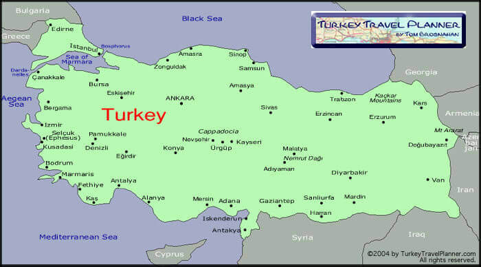
Touristic
Map of Turkey
Most of the places you'll want
to visit. Click on a name and info
will appear in a new browser window
(so you can still see the map, too.)
Turkey's
Regions & Major Cities
Simple, clear map of the country with its major cities.
Click on a name for more info (in a new window).
Turkey's
7 Climatic/Geographic Regions
More than just the weather: it's like seven distinct
little countries, each quite different. Click on
a region name for regional weather and climate info.
Turkish
State Railways Train Route Map
Want to know where Turkish trains
go? Here's the map.
Turkey Country Map (HEMA
Maps)
Excellent, clear 1:800,000 map of Turkey,
including driving-distance chart and
city-map insets for Istanbul, Ankara,
Izmir & Antalya. Good highway and
touristic-site info. Great for planning,
cumbersome on the road: it's
3ft x 4ft (1x1.2m), and the front side
is of eastern, not western Turkey.
10%
discount for TTP users: click
here & use
coupon code
"TTP".
Turkey Highway Map (from
Tulumba)
Turkey Touristic Highway Map (from
Tulumba)
Turkey Touristic Highway Map -
Large Size (from
Tulumba)
Turkey Map - Cartoon Style (from
Tulumba)
Turkish Inter-Village Road
Atlas (from
Tulumba)
REGIONAL & CITY
MAPS
Istanbul, Street Plans, Istanbul Region,
Asian Shore, Bakirköy, Besiktas,
Beyoglu, Bosphorus, European Shore,
Kadiköy, Kumkapi, Nisantasi, Ortaköy,
Pera, Sile, Sisli, Sultanahmet, Üsküdar,
Yesilköy More...
Bursa, Çanakkale,
Istanbul Region, Izmit (Kocaeli),
Sea of Marmara Region More...
Aegean
Region, Aydin, Didyma, Bodrum, Bodrum-Marmaris
Region, Çanakkale, Çesme, Denizli, Izmir,
Izmir Region, Kusadasi, Pamukkale, Sea
Charts More...
Adana,
Alanya, Antalya, Antalya Region,
Belek, Dalyan, Datça, Fethiye,
Kas, Kalkan, Kemer, Köycegiz,
Manavgat, Marmaris, Mediterranean
Region, Mersin, Side, Tarsus, Sea
Charts More...
Ankara, Cappadocia More...
Black
Sea Region, Sile More...
Country Maps, Turkish Inter-Village
Road Atlas More...
Lonely
Planet Istanbul Map
Where
to Buy Maps of Turkey
Where
to Go
When
to Go
Transportation
Site
Index
Travel
Details
Turkey
Travel Planner Homepage
|
|
 |
|
Here's an Istanbul
map used a century ago
(see below for more).
|
|
|
|
The large inscription
at the top of this column reads Haliç-i
Der-Saadet, or "Channel
of the Abode of Felicity." Der-Saadet—"Abode
of Felicity"—was Istanbul's
official Ottoman name.
It's easier
today: Kemal
Atatürk converted
Turkey to the Latin alphabet in
1928.
(Believe it
or not, I spent two years of
my life learning how to read
old Ottoman legal
documents. Oh yes I did. Read
about it in Bright
Sun, Strong Tea.)
|
|