

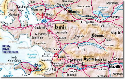
Here’s a map showing Izmir and nearby towns: Aydın, Çeşme, Foça, Kuşadası, Manisa, Menderes (and its important airport), Nazilli, Selçukand Söke.
Ancient cities shown on the map include Claros, Colophon, Ephesus [Efesos Harabeler], Magnesia ad Meander, Priene and Sardis. Just off the map are Miletus (south of Priene) and Aphrodisias (east of Karacasu).
The big river flowing from east to west at the bottom of the map is the Great Meander River (Büyük Menderes Nehri). Its twisting course near its mouth on the Aegean Sea gives us the English word for a river that twists and turns.
For more detailed fold-out maps of Aegean Turkey, Aydın, Çeşme, Didyma, Izmir and Kuşadası, click here.


 Best Travel Agencies