

Unlike most of Eastern Turkey, the southeast is not mountainous but rather an arid plateau at around 600 meters (2000 feet) elevation. The region is more or less bounded by those great historic rivers, the Tigris (Dicle) to the east and the Euphrates (Fırat) to the west (maps). Many of the people here are Turkish citizens of Kurdish descent.
The region was a crossroads of civilizations in Biblical times and even earlier. The patriarch Abraham lived for a time in Harran, south of Şanlıurfa. To the Crusaders, Şanlıurfa was the Latin County of Edessa. Mardin and Midyat have Syriac monasteries where services are still chanted in Aramaic, the language of Jesus.
The land can be fertile if irrigated, which is why the Turkish government has invested decades of work and trillions of Turkish liras in the Southeast Anatolia Project. This mammoth public works endeavor, known by its Turkish initials as GAP, has brought dozens of dams and hundreds of kilometers of aqueducts to the region, hugely increasing its capacity for raising crops and supplying electricity. This once poor region is beginning to show the results of huge long-term investment.
The best times to visit are spring (March, April, May) and autumn (October-November). In July, August, and September, the sun blazes, and there's rarely a cloud. In the winter, it can be chilly.
Top Destinations
Southeastern Turkey is one of the most culturally diverse locations in Turkey. Cities such as Diyarbakır, Mardin, and Gaziantep have been one of the backbones of civilizations throughout the years. Today, you can visit this rich region and witness its full glory.
Keep in mind that some cities in Southeastern Anatolia were damaged during the 2023 Turkey-Syria earthquakes; however, works are being done to renovate the affected areas and repopulate the region.
Here's what to see and do:
Diyarbakır
Diyarbakır (also known as Diyarbekir) is the largest city in the Eastern Anatolia region. Diyarbakır, with its mighty black basalt walls looming over the fertile banks of the Tigris, The city walls were built by the Romans, who named the city Amida. Throughout the years, Diyarbakır would be conquered by Persians, Arabs, and the Ottoman Empire. Today, the walled city still retains much of its medieval air, not to mention its street pattern. Keep in mind that many citizens of Diyarbakır are Kurdish-origin Turks.
Top Sights
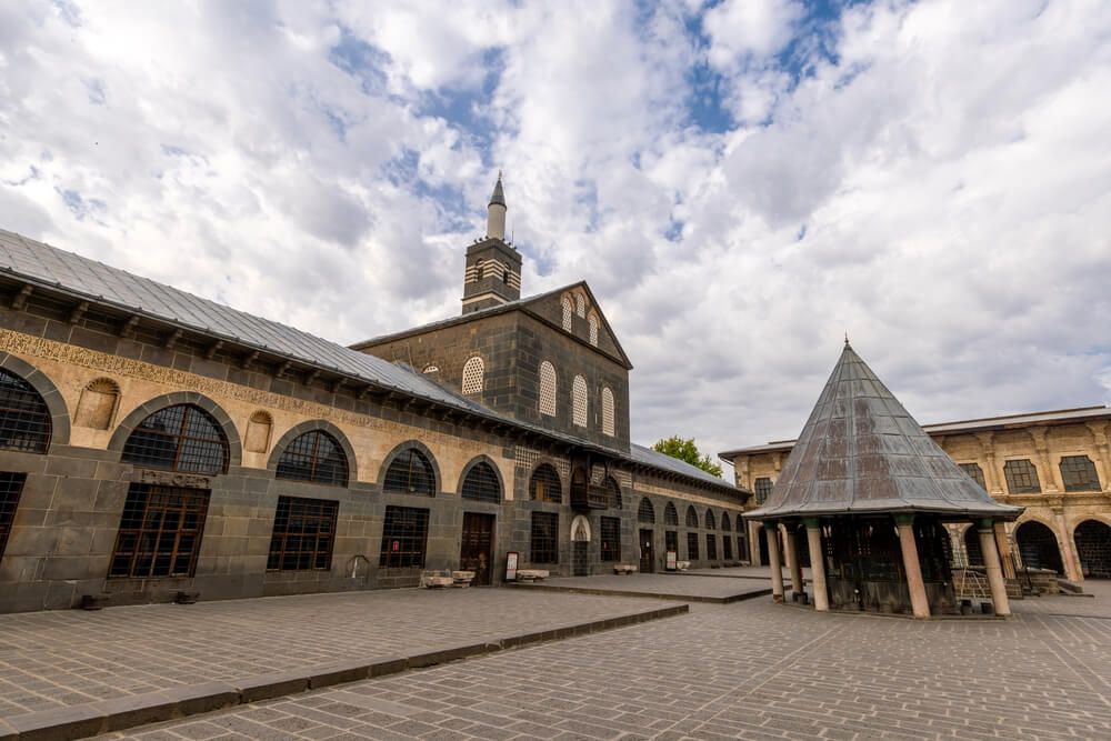
The Great Mosque of Diyarbakır (Diyarbakır Ulu Cami): This amazing mosque was built in the late 11th century by the Seljuk sultan Malik-Shah I and is one of the oldest mosques in Anatolia. Definitely worth a visit!
Surp Giragos Armenian Church (Ermeni Kilisesi): This Armenian church is located on the same street as the Great Mosque of Diyarbakır and is the largest Armenian church in the Middle East. Built in 1515, this magnificent church used to accommodate 3000 worshippers at a time!
Sülüklü Han: Sülüklü Han was once a caravansary and believed to possess leeches that can cure any sickness. Today, it is a bustling cafe and terrace where you can enjoy traditional Turkish tea and Turkish coffee.
St. Mary Church: St. Mary Church was built as a pagan temple in 1 B.C. and turned into a Syrian Orthodox church in 3 B.C. Today, it is one of the few churches in Turkey where they read the Bible in Jesus Christ's mother tongue, Aramaic.
Diyarbakır Fortress (Diyarbakır Kalesi ve Arkeoloji Müzesi): Built around 4 B.C. by the Romans, Diyarbakır Fortress' long walls are accepted as the longest wall structure after China's Great Wall. It is also a Unesco World Heritage Site. Inside the fortress, you can also visit the Diyarbakır Archaeological Museum, Saint George Church, and Ataturk Museum.
Southeastern Turkey Tours & Experiences
Here are the most popular guided experiences across Turkey’s Southeastern Anatolia region:
Gaziantep
The business and finance capital of the southeast, Gaziantep (also known as Antep), is known for its pistachios and the baklava made from them. It's a very old city, yet only a few bits of its antiquity remain. However, you can still visit some pretty impressive ruins and sites.
Top Sights
Gaziantep Castle (Gaziantep Kalesi): Gaziantep Castle first started its journey around 2-4 B.C. and was used as an observation tower by the Romans. However, it was damaged during the 2023 Turkey-Syria earthquakes and is now under restoration.
Gaziantep Emine Göğüş Culinary Museum: Gaziantep is one of the culinary capitals of rich Turkish cuisine, so it is no wonder why there is a museum dedicated solely to culinary As of November, it is under renovation, so make sure to check availability before visiting.
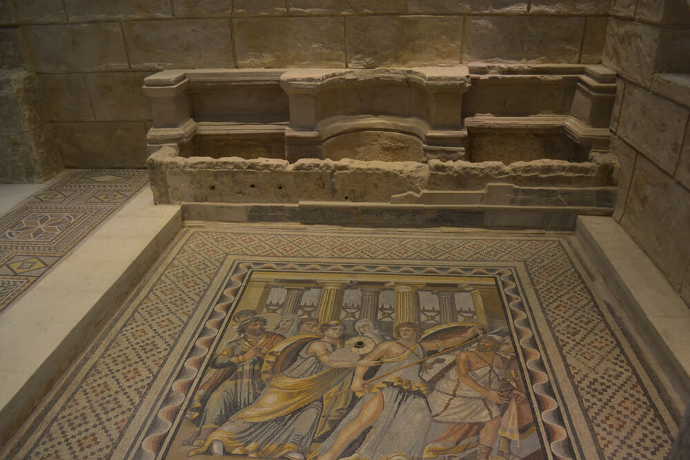
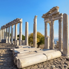
Zeugma Mosaic Museum (Zeugma Mozaik Müzesi): Zeugma Mosaic Museum is the world's largest mosaic museum, featuring 2.448 m² of mosaics from the Roman and Late Antique periods. There are also fountains, statues, and fountains.
Liberation Mosque (Kurtuluş Cami): Kurtuluş Cami, formerly the St. Mary's Cathedral or Holy Mother of God Church, was an old Armenian church that was converted into a mosque. However, you can still see the original building and some of its artifacts.
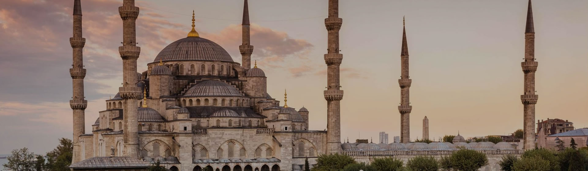
Şanlıurfa
Urfa, as it's commonly called, has a rock promontory at its center crowned with an ancient fortress. At its foot is a sacred pool and the reputed birthplace of the Patriarch Abraham. It's a popular place of pilgrimage for Muslims, with a fascinating bazaar and a few fine old buildings. It's also the best base for visits to nearby Harran and the world's oldest known religious site, Göbekli Tepe.
Top Sights
Cave of Abraham (Mevlid-i Halilulrahman Mağarası): This is the historical site where Prophet Abraham is believed to have been born. There are also mosques and a park with a pond. The pond and the fish inside are believed to be sacred. As the story goes, this is also the place where Nemrut tried burning Abraham, but God turned the wood into water and the coals into fish.
Şanlıurfa Castle (Urfa Kalesi): Urfa Kalesi is the ruins of an ancient fortress; it is located just next to the Cave of Abraham and provides a breathtaking view of the site.
Kizilkoyun Necropolis: Dating back 2000 years, this is the necropolis of the Edessa Kingdom, which has Roman tombs, reliefs, and mosaics.
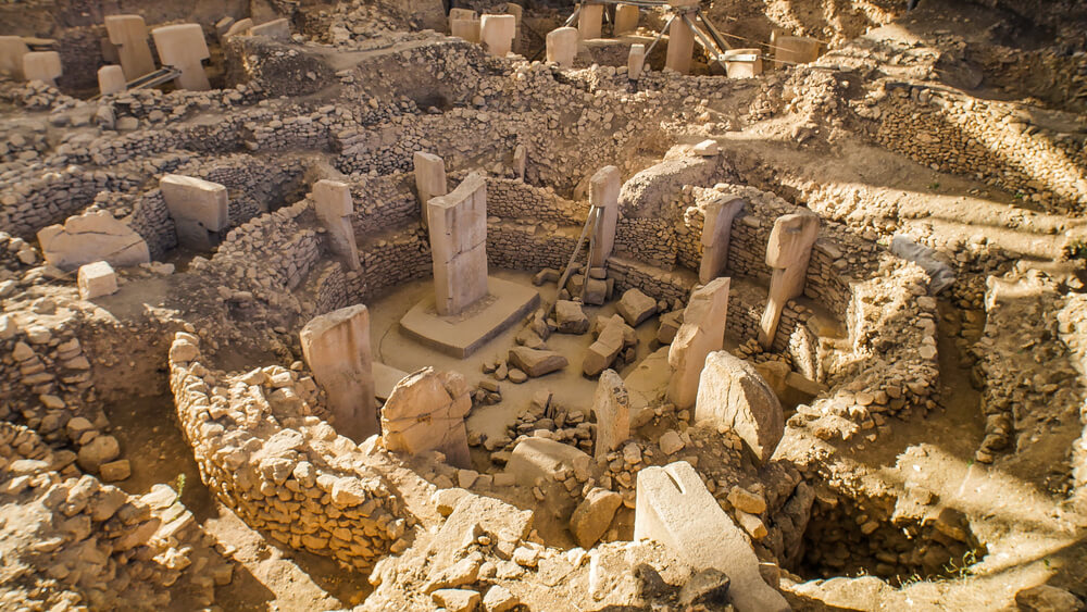
Göbekli Tepe: Göbekli Tepe, built by the nomads in the region, is the oldest religious site known to humans. It is an 11,000-year-old temple complex that was discovered near Şanlıurfa. If you have any interest in history or archeology, you simply have to visit it. Archeologists say, "It changes everything."
Harran: An astounding sight: a warren of beehive-like mud houses rising from the Syrian plain. Harran (a municipality of Şanluurfa) looks like it has been here forever—and it has, ever since the Book of Genesis, at least.
Kahramanmaraş
Yet another ancient town has now grown into a modern city with little to show for its long past. Kahramanmaraş (or simply Maraş) has decent hotels if you need a place to stop. It's famous for its ice cream, which is so thick with a binder that you can hang it on a hook for display. Keep in mind that Kahramanmaraş was deeply damaged during the February 6th, 2023, Turkey-Syria earthquakes and is currently under renovation.
Top Sights
Kahramanmaraş Castle (Kahramanmaraş Kalesi): Built between the 1st century B.C. and the 2nd century A.D., it is a hilltop castle in the middle of the city.
The Covered Bazaar of Kahramanmaras: Believed to date back to the 16th century, this covered bazaar can be a good stop for shopping for souvenirs.
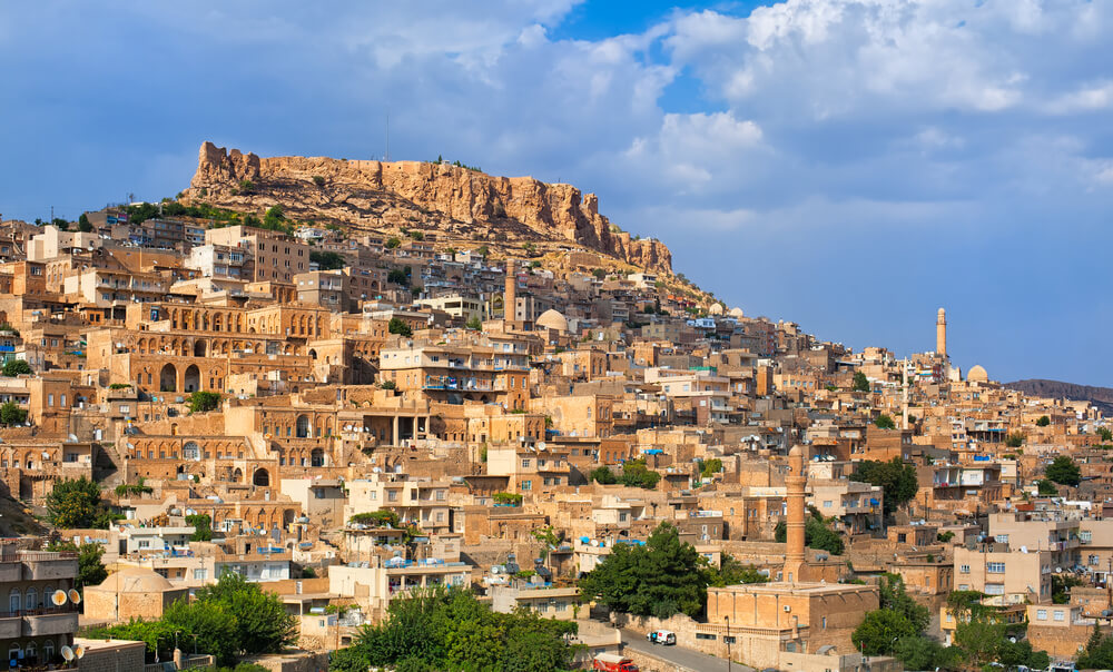
Mardin
This city is one of the most stunning spots in the area. Perched at the edge of a plateau looking out over the Syrian plain, Mardin has several impressive oldish buildings (1300s and later), but the Assyrian monasteries around Midyat in the Tur Abdin region to the east are far older, some dating from the 5th century.
Top Sights
The Sultan Isa Medrese or Sultan 'Isa Madrasa (Zinciriye Medresesi): Built in 1358, this ancient madrasa has some of the most stunning scenery in the city.
Kasımiye Madrasah (Kasımiye Medresesi): is another ancient madrasah in Mardin. This elegant structure also houses some of the most impressive sunset views and a beautiful pond. It dates back to the Artuqid dynasty of the 13th century.
Forty Martyrs Church (Mor Behnam) Church: Kırklar Church is an impressive church dating back to the 4th century.
Mardin Castle (Mardin Kalesi): Built almost 3000 years ago, this ancient fortress is now used as a military base. Do not try to go beyond the barbed zone, as you can only observe its magnificence from far away.
Nemrut Dağı

Because it's up in the mountains rather than on the plain, Nemrut Dağı, Adıyaman, Kâhta, and Malatya belong more to Eastern Turkey than to the Southeast. But Nemrut Dağı, the mountain, and its colossal statues are easily accessible from the cities of the Southeast, so you may want to combine visits to them.

 Best Travel Agencies